Showing posts with label water. Show all posts

Tuesday, 29 December 2015

The long and winding road…


After a day trapped inside, ambushed by the deepest, dankest monsoon, Sunday’s dawning brought with it a spectacularly clear sky: and only the northern Pennines, morphing into the majestic Howgill Fells, just waking, to my right – constant, lumbering, reclining colossi – were still snugly covered beneath the cotton-wool-drifted quilt of rising dawn moisture, softening their sharp bulk.


Leaving the motorway, and arriving in the Lake District proper: as I passed Scales on the main road, those majestic mountains reared up in front of me – Blencathra almost friendly, welcoming – glowing a glorious rich russet; with their own topping wisps of remaining cloud floating away, lazily and gently, on the surprisingly lethargic breeze.

All the way, I had followed the sentinel just-past-full moon – a guardian and a guide – the low, bright lunar globe leading me to the turning I wanted at Braithwaite; before descending to its own long orbiting sleep behind the north-western summits.

Hugging the Derwent Fells, the familiar narrow road leads to a small, ancient bridge just before Birkrigg – but mouldered now into the grown-riverlike Rigg Beck beneath – the first vestige of the struggles I had, thus far, only seen in the news. Fortunately, the gushing ford that ran next to the footbridge was passable – but only with immense care and forethought. Had I not a vehicle designed to conquer such challenging terrain (and the knowledge to go with it), I would have mourned my annual return to “the lake by the dairy pastures”; but, surely, in this small paradise, readily found another delightful destination. (Cartmel – which my iPad’s autocorrect decided should be “Caramel” – which seems apposite – Priory, again, maybe; or “old man’s mountain” Gummer’s How – surely, on such a glorious day, one of the Lake District’s more achievable, and far-seeing, vantage points? (In August, visibility had been minimal; the ascent and descent treacherous; the weather then damp, belligerent, and bitter.))


Having waded through this first obstacle, still I went on with deep trepidation. At points – especially the final descent, beyond Newlands Hause – torrents of water rendered the 25% inclines deceptive, untrustworthy waterways. Landslips had mostly been cleared; but the surface of the road was littered with debris: mud, wrack, tangled branches, scree. My 4x4 was as sure-footed as a mountain goat, though: enabling me to concentrate with long-held breaths, and steer slowly and cautiously to my morning’s destination.


I was the second to arrive at Buttermere: chatting for a while with the seasoned, hardy soul about to set off to reconquer Haystacks and the ridge along Seat, High Crag, High Stile, Red Pike, before returning via Dodd and Old Burtness.


His love for the mountains was obvious: as was his preparedness. He, too, had arrived via challenges and setbacks – but also would not be thwarted in his goal!


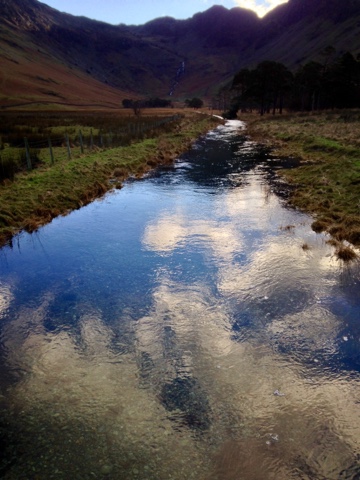
I parked next to Mill Beck, which feeds into Crummock Water. It bubbled and frothed with a rabid anger that had not only destroyed the fences which usually ran alongside, but filled me with a foreboding that I would not be able to complete my planned circuit.


No snow remained: although torrents poured down from every crevice. Water, water everywhere – turning roads and paths into rivers, streams, and sometime waterfalls.


The walk itself was more hazardous than in previous years: well-trodden ways now well under water; sodden ground; routes blocked by serried, toppled, shallow-rooted pines. At one point, I had to scramble along a short rockface: hunting with amazed joy (and the memories of long-forgotten youthful climbing) for hand- and foot-holds – true crag-hopping (albeit in extreme slow-motion) – before descending to the remains of the eroded, slate-pebble-dashed path below. (My damaged body will take weeks to recover from this punishment, I know. But my mind will leap forever with joy at each similar memory.)


Conditions could have been so much worse: recent wrack-marks demonstrated how much higher the mere had lapped – obliterating any chance of traversing its shoreline.


Just past the obstacle course of fallen trees, I encountered a toddler (with justifiably proud mum) entranced with my reflective sunglasses, bush-hat and fingerless gloves. This was one happy child – with an even better outfit than mine! – determined and communicative; and aiming to complete the circuit with a big grin that warmed the heart. I truly hope they succeeded. They deserved to on such a day; and with such spirit.


But, of course, everyone I encountered said hello. Some stopped to chat, as well; and there was a comradely courtesy – holding gates open; advising about obstacles ahead; suggesting diversions… – but all of us glorying in the sunshine hovering above us.


At this time of year – even when all the sun can do is paint the sky a vivid cobalt, and tint the surrounding, cradling peaks with gold flames, without ever reaching the mere itself – this remains such a beautiful, yet sometimes harrowing, place: the true definition of the ‘picturesque’.


I must have been born without the traditional-English-stiff-upper-lip gene: and, as a result, there is a direct line drawn from external, ineffable beauty – whether that be music, art, poetry, sculpture, landscape… – to the core of my creative, sensitive, romantic soul.


Standing once again on Peggy’s Bridge, at the entrance to the Scarth Gap (I expected orcs), gazing back towards my starting point below High House Crag – Haystacks and Fleetwith Pike glowering menacingly dark behind me…… – dear reader, I admit that, silently, I cried.


The overwhelming assault of magnificence flooded my senses. (There was no room, today, for music.) Truly, this is a place where there is a surfeit of glory and grandeur – enough to emotionally sustain one for a lifetime.


I do not believe in any deity – yet this felt like an epiphany, a conversion (albeit on the path to Gatesgarth Farm).


As I returned to the sanctuary of my car, I was rewarded with one of my favourite sights: four keen Border Collies, expertly controlled with the subtlest of commands, manoeuvring a small flock of muddy Herdwicks to less waterlogged pastures.


Such skill; such innate teamwork; corralling them seamlessly and cohesively through a series of gates along narrow tracks. The oldest dog had a withered rear leg – but this was no impediment – this was an independent, sharp spirit, tugging at the boundaries of control, and obviously gleeful in its well-earned freedom.


Later, with such perfect weather for wandering – although, returning to my hotel, I would discover that my cheeks and forehead had been sanded rough and raw by the prevailing wind – the car park behind the Fish Inn grew full; and the paths and roads around the mere grew busy with companion walkers and cyclists. (Last Christmas, I departed as only the second car of the day arrived – such was its peace.) Such busy-ness, this time, made the place safer, though – essential when each turn of a corner presented unexpected vistas and occasional risks.


Not wanting to repeat my morning’s daring adventures, I returned to the A66 via the Honister Pass (which I had been told by my earlier associate was clear and dry) – pausing below the rugged, stunning Seatoller Fell to wonder at the surrounding might. Beautiful Borrowdale (I expected hobbits) glowed golden and welcoming, below, bathed in a beautiful, warm, umber light. But, beyond, yet more stark evidence – an almost infinite sea, where Derwent Water had once lain peacefully: at some points reaching out to stroke the road’s edge. In Keswick, the worst-affected households were marked by cairns of damaged white goods and furniture – and yet the town was very much buzzing with life.


This had been Buttermere at its very best: not as placid and tranquil as perhaps it can be (and is often imagined). But the Lake District as a whole is still struggling: and needs as many visitors, as much help – along with Lancashire, Calderdale, etc. – as it can get. Go visit! Cumbria is open! (But please – with Storm Frank on the way – be careful out there.)


Monday, 28 September 2015

A canal (or two) runs through it…


The construction of the Abbeys is a marvel to behold, for in a day when fresh water was a concern, the Cistercians had plenty. They always sought out locations that were secluded and on a running river or stream. The monks would dam sections to create enough flow to carry water to every portion of the Abbey. Water would flow through kitchens, to basins for washing and they even had indoor plumbing where waste would drop into the river and be carried away from the Abbey.
– TemplarHistory.com: The Cistercians

I remember the venerable (and much-missed) Mick Aston once, during an episode of Time Team, describing the Cistercians as “God’s plumbers”: due to the way they so perfectly tamed their surroundings…

…clearing woodland and scrub, draining marshes and building canals, mills and fishponds. Even though such activities by Cistercians may have been over-emphasized by researchers in the past, and such landscape changes were in any case widespread by the twelfth century, [knowledge of engineering skills in building and water control, together with the means to use it] was nevertheless a major aspect of early Cistercian monasteries to modify dramatically the landscape in which they were built.


His soubriquet came to mind whilst pootling along the short section of the Heart of England Way between Baddesley Clinton and the junction, at Kingswood, of the Stratford-upon-Avon Canal with the Grand Union Canal (the latter, one of the pinnacles of mankind’s “hydrological innovation”; and – one could say, with ironic tongue in sardonic cheek – the HS2 of its day… – although I will always prefer the Leeds and Liverpool for its infinite variety, and the cherished memories formed walking along many, many miles of its towpaths during my youth).

There may be no obvious Cistercian-required “running river or stream” in this Warwickshire locale – but I believe that the monks would be impressed, looking down from their quiet version of heaven upon these now-generally-peaceful “motorways of the 1700s”, to see their “knowledge of engineering skills” (evolved from those of the Romans, of course) put to such elegant use (and so very well‑maintained).


Back at Baddesley, survey work carried out for the National Trust in late 1994 confirms just how much “water control” has been instituted during its long and engrossing existence:

A wooden sluice was exposed near the south-east corner of the moat. This is probably the finest example of its kind recorded systematically in the United Kingdom. Survival of such features in wood is extremely rare, and the author knows of no other intact example archaeologically recorded….
     The sluice structure appears to be a very well-preserved example of a sluice type commonly in use today, and known as a ‘monk’. The name implies monastic invention, but the association between monasteries and hydrological innovation is not now so readily supported by more recent research than was once considered. The slotted area in front of the back wall was probably intended to take removable wooden boards, which were inserted to hold the water in the moat, and removed when the moat needed draining. These wooden boards would be fitted loosely initially, but on swelling from contact with water would have made a waterproof fit. The ‘monk’ sluice is extremely efficient when used on water features that require regular draining and maintenance. They are the most popular sluice type in use today amongst fish-farmers, and are of an ancient design that probably dates back, in its simplistic form, to at least Roman times…. It is not possible to give a date on present evidence, but there is no reason why such structures should not be medieval in origin. The present example, however, has probably been replaced on a number of occasions, and is probably the latest example of a long succession of similarly designed sluices used to control water in this particular moat.


Poring over the Ordnance Survey map for the area, as is my wont, it is readily apparent that the Baddesley Clinton estate is as much defined by the amount of light-blue ink – despite that lack of a major indigenous waterway (although the water table appears to be quite close to the surface, in places…) – on the page, as by its remarkable, beautiful, historical and welcoming architecture. In fact, a comparison with neighbouring Wroxall Abbey – “In medieval times… a small Benedictine Convent” – although this is probably due to the manor-house’s more recent and continual habitation – demonstrates just how “dramatically” the local landscape has been sculpted. (The Poor Clare Community – their convent still visible on the road to Baddesley – was a much more modern establishment.)

For instance, there is an apparent leat – or, at least, a diverted and enlarged brook – heading down a hollow towards the manor from the direction of Hay Wood; and a well, not far off, in Church Field – although this may have been part of “a small village, possibly never very large”: as there are evident remains of ridge-and-furrow, despite several centuries of grazing and hoof-trampling. And then there is, of course, the famous “Moate” (originally one of a pair): connected to the Great Pool (with its twin islands), Long Ditch, and brace of “stew ponds”.

There are also other notable (but relatively diminutive) bodies of water between the aptly-named Mill Meadow and New Wood; as well as a more obvious pair (probably also fishponds) feeding towards this, at the junction of Lime, Barn and Little Church Fields. As Aston writes: “often fishponds were linked to systems of water supply, drainage and mill complexes in elaborate water control and management operations”; and it is nigh impossible, therefore, to believe that the coincidence of the supplying streams and ditches with the unbending field boundaries that join these bodies of water together is natural – a suspicion confirmed by the National Trust’s earlier appraisal (also quoted above):

One of the most interesting items in the medieval deeds, relate[s] to the recording of a mill associated with a fishery in the 1440s. Roberts records three demesne ponds in Baddesley Clinton between 1443 and 1448. These are called Lydgate Pool, Black Pool, and Milne Pool. It is probable that the Milne Pool is the fishpond recorded associated with a mill. The 1699 map records two fields adjacent to the Great Pond west of the moated site, as Mill Meadow and Mill Field, thus seeming to establish this pond as the site of the medieval mill. The mill is recorded in a number of later documents extending from 1531 through to 1668, after which date it is not recorded again….
     There are at least a dozen ponds of reasonable size shown on the 1699 map. Any one of these could have existed in the medieval period, either as a purpose built pond similar to the Mill Pond, or as quarries that later filled with water, and were subsequently used as fishponds.
– Christopher K Currie


There are many fascinating and picturesque (as well as beautiful and sublime) walks in the area around Baddesley Clinton, Hay Wood and Rowington Green – as well as nearby Packwood House. But simply ambling around the grounds can be its own reward – especially as the sun can be observed, through the day, streaming around the three extant wings of the manor, glinting in the moat and pools, during the generous opening hours – time easily occupied in admiring the wonderful gardens (the Walled Garden’s dahlia border – despite my dislike of the individual blooms – is stunning at this time of year; and it was sad to see some of their ‘dead heads’ discarded on the array of Vegetable Garden compost heaps); resting on the many surprisingly secluded seats (where the lesser-spotted Bard may be found: gazing at some drama’s text; or into the distance, chortling quietly at the squabbling ducks); meandering along the winding, easily-traversed, paths – and, of course, savouring the superb, freshly-cooked food and -brewed coffee (Bard-fuel) in the airy Barn Restaurant.

You could even – should the fancy take you – wander across some of Warwickshire’s most pleasant green fields and byways (including alongside both canals) to Packwood itself; and there are many local hostelries in the area at which to quench any resultant thirst (including the wonderfully-named, slightly quaint, The Case is Altered – also, coincidentally the title of a play (partly?) by Ben Jonson…).

You don’t even need to take the car: as Lapworth Station is a mere thirty-minute walk away (from both National Trust properties); and only nineteen minutes travel from Stratford-upon-Avon on the rare-as-hen’s-teeth direct London Midland service (although the more frequent London Midland/Chiltern Railways journey is around fifty minutes – with around half of that time spent sitting on the platform at Dorridge Station, waiting for the all-of-three-minutes second leg…). And even the railway line is as scenic as one could ever hope for….

By now the sun of afternoon
Showed ridge and furrow shadows
And shallow unfamiliar lakes
Stood shivering in the meadows.
Is Woodford church or Hinton church
The one I ought to see?
Or were they both too much restored
In 1883?
I do not know. Towards the west
A trail of glory runs
And we leave the old Great Central line
For Banbury and buns.